The Great R'Idaho Trail #1
Nevada to Canada - Route Description
Stage 4: Burgdorf to Pierce
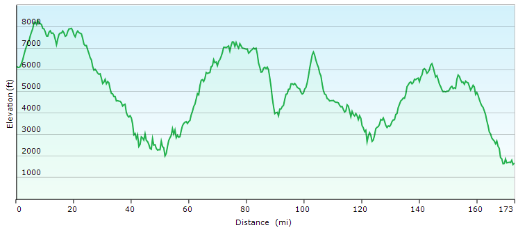
Distance in Miles
Miles of Trail
Minimum Elevation in Ft
Maximum Elevation in Ft
Interactive Maps To See Detailed Route.
(Full Screen) Download GRIT1-N2C Tracks
Legend
- Red: Designated motorcycle trails with Most Difficult/Advanced rating.
- Navy Blue: Designated motorcycle trails or notably tougher ATV trails
- Green: Designated ATV trails or just too easy motorcycle trails
- Magenta: Roads. Dirt Road most often, but occasionally paved.
- Light Blue: Easier Bypass Detours or optional side-trips. Only the first section of a detour is color coded when the route splits.
- Black: Special Test Detours. Only the first section of a detour is color coded when the route splits.
 We have included an optional easy morning loop to explore Loon Lake and the WW-II era bomber wreckage along with 4 miles of river side singletrack because there is just so much to see in this area. This is probably best fitting for those riding in Pioneer or Explorer style.
It can be hard to leave the serene atmosphere of Burgdorf Hot Springs, but when you do, it is a short dirt road out to Nethker trail that climbs up to the flowing ridge top Bear Pete Trail for 15 miles of highlight trail. At the end, we drop 4,500 feet on the French Creek road down to the Salmon River. The Salmon river road (NF1614) takes us due west for about 10 miles where we have another option. We can cross and continue down the Salmon River and go directly into Riggins via 10 miles of paved road for a quick detour to get extra gas. But if we have enough gas range (156 miles for standard track if you gassed up at Burgdorf) to make it all the way to Kooskia, we can skip the detour to Riggins and save nearly an hour in our day.
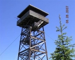
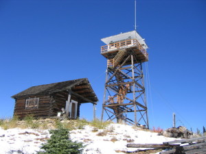 From the Riggins detour departure point, the standard route turns up Allison Creek Rd to climb from 1800ft to Chair Point Lookout at 7000ft. After visiting the working lookout, we take a short road north to split off onto the ridge line trail 118 and 117 for 6 miles that roughly parallels the Slate Point road. This trail is faint and can be hard to follow, but there is little underbrush and ribbons on the trees and bushes to discover to help you make your way through. Near the trail head to trail 307, there is a short spur trail up to the top of Slate Point, which is short, but so windy and open that it is fun speed racer time. At the top, you can go back down the same trail, or take the parallel road back , or start the advanced difficulty special test loop (No Business trail 349 and NF Slate Creek trail 320) before rejoining the main route later. But the main route takes trail 307 (called Pack Trail 309 on some maps) and Telephone Ridge Trail 329 for 6 miles. This is a designated MC tail, but the ATVs have taken it over.
 From the end of Telephone Ridge Trail, we get a 12 mile dirt road breather before a short ATV trail and then 9 miles of the highlight Marble Point ST trail 328 along some pretty terrain. Then we go 19 miles of dirt road to follow ATV trail 421 for 9 miles before we cruise on the historic Elk City Wagon Road for 28 miles of gorgeous dirt road scenery into Kooskia for gas. Then it is 50 more fast ADV quality dirt roads into Piece for the end of the stage and full services.